Ord is a favored site for hard core Valley birders because of a geographic fluke. It lies just inside the northeast boundary of Maricopa County. If you happen to keep a county list, Ord harbors several high elevation breeding season species found nowhere else in the county. If you're not a lister, it should be on your short list of future birding destinations anyway because most of those species are either drop dead gorgeous or relatively uncommon elsewhere in the state due to restricted habitat.
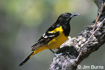
Painted redstart, Grace’s and olive warbler, and western and hepatic tanager fall into the former category, gray vireo and black-chinned sparrow into the latter. The beautiful lemon and black Scott’s oriole qualifies in both. Ord is also home to Cooper’s and zone-tailed hawks, golden eagles, and spotted and northern pygmy-owls, though these raptors are not often seen.
Most birders make two stops on Ord. The first is at Forest Service Road 1688, about halfway up. Don’t even consider driving up this 4x4 trace, but an early morning walk will produce the vireo and the sparrow along the southwest facing chaparral slopes. Continue on the main road around the back side of the mountain to the locked gate. A hike to the lookout should give you warblers and tanagers. Both areas offer open vistas. Watch for raptors overhead and try not to notice the brown cloud over Phoenix.
I once had two flats on Ord in the space of ten minutes--funny in retrospect. A week after Virginia Tech I encountered two shooters in full camouflage--funny if you like adrenaline rushes. And, this spring, a strange woman almost jumped in my van--just plain funny.
As I was driving down the mountain, another van was backing out of 1688. Unsure whether he saw me, I zipped past, topped a rise, and encountered a birder walking slowly right down the middle of the road not ten yards from my front bumper, her back to me. Completely oblivious of me, she pointed left as a western scrub jay flipped downslope, then right at a Bewick’s wren upslope. As I crept the van up slowly so as not to startle her, she moved off to the side and, never taking her eyes off the hillside, opened my passenger door, put her foot on the step, and began climbing in. Did I mention this lady was a total stranger?
It turns out that was her husband driving the other van. It was laugh out loud funny. If she’s reading this now, I hope she’s not embarrassed. I totally admire her focus and intensity that day, essential qualities for any serious birder. Visit Ord soon—great birds, funny stories, always an adventure.